Coastal Erosion Hotspots in Western Australia
In 2019 and Assessment of Coastal Erosion Hotspots in WA identified locations where coastal erosion is expected to have a significant impact on public and private property or infrastructure in the next 25 years.
This study identified 55 coastal erosion hotspots in WA — 15 in the Perth metropolitan area and 40 in regional areas.
An additional 31 locations (8 metropolitan, 23 regional) were placed on a watch-list for future monitoring and investigation.
The assessment was commissioned to help evaluate the scale and extent of coastal erosion in Western Australia and demonstrate how the risk to the natural and man-made environment at each location is expected to increase over time.
By better understanding risk, local coastal managers can make informed decisions that support sustainable land use and development.
The CoastWA program aims to address the findings and recommendations of the Assessment of Coastal Erosion Hotspots in Western Australia.
DTMI identified a need to review and update the original assessment to examine changes and understand the role of CoastWA to date through WA Coastal Erosion Hotspots.
The review suggests hotspots can be reranked in management importance after consideration of changing risks, funding allocations and work undertaken between 2018/19 to 2024/25. It recommends an overall net reduction down from 55 to 48 locations, despite the addition of four new hotspots.
Overall, the review found that over half of all hotspot sites may be either downgraded in severity or reclassified to watchlist status following the successful outcomes of CoastWA.
The review recommendations are preliminary and will be examined by a formal hotspot reassessment consultancy due in 2026 for verification and confirmation.
A Statewide Coastal Inundation Assessment for WA
Australia’s coastal inundation risk is growing with rising sea levels, changes to climate and weather patterns and increasing coastal development. Here, WA coastal communities are an important part of our way of life.
Nearly 20 per cent of WA homes and 30 per cent of commercial buildings are located within one kilometre of the coast.
Although coastal inundation is often considered a secondary coastal hazard in WA compared with coastal erosion, the threat of sea level rise impacting large areas of our coastline is a significant issue.
To better inform and support local communities, the Department of Transport and Major Infrasturcture (DTMI) has undertaken a strategic state-wide assessment of coastal inundation. The study maps the potential inundation threat during the next 25 years, determining the risk to coastal communities and examining pathways to manage the threat.
Frequently asked questions
Flooding caused by the actions of the sea is coastal inundation. Flooding is the covering of normally dry land with a large amount of water. This can occur through effects of rainfall causing overland runoff or expanding of rivers, or via actions of the sea, including tides, waves, and storm surges, also known as king tides. Coastal inundation is generally temporary, but with climate change projections over longer timeframes, it will occur more often, for longer periods and can become permanent.
Understanding the extent and impacts of current and future inundation events is essential for state and local managers to strategically plan for and manage coastal inundation. The study has identified both state-wide strategic and location specific targeted actions to address inundation hazards.
The need for an inundation assessment was identified in the Assessment of Coastal Erosion Hotspots in Western Australia, and the inundation study has been funded and delivered through the CoastWA program in partnership with Department of Planning, Lands and Heritage (DPLH).
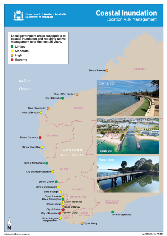
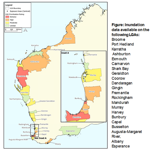
The study examined the potential scale and extent of coastal inundation over the short to medium term across 45 coastal local government areas, identifying 23 specific at risk locations.
The most significant sites for coastal inundation management are at Bunbury and Busselton, with extreme susceptibility to coastal inundation identified at both. While both are actively managing existing risk through use of protective structures, exceptionally large events above typical design levels could overwhelm existing defences. The City of Busselton is currently undertaking detailed investigations into its coastal inundation management.
Carnarvon is also identified as having extreme susceptibility to coastal inundation due to its low elevation. The study recommends an economic review for Bunbury and Carnarvon to investigate in detail whether the current standard of protection is appropriate.
Coastal inundation is typically caused by tropical cyclones in the North West and winter storms or cold fronts in South West. In the future sea level rise will raise water levels, the impacts of this will be felt during storm and cyclone events. Future higher water levels plus storm surge will lead to more frequent coastal inundation events with larger extents and depths.
As the climate changes there will be impacts such as increased degradation of beaches, damage to existing coastal structures and increased frequency of inundation events that threaten private properties and public assets in high-risk areas. By understanding the threat we can proactively plan to minimise its impacts.
The study is designed to help local land managers plan, design and budget mitigation measures and seek Commonwealth and State funding. The report will also be used by the State Government to identify priority actions to strategically support management of inundation hazards.
The study identifies targeted actions for managing inundation hazards at 23 specific locations that will support and benefit future studies, works and local government Coastal Hazard Risk Management and Adaption Plans (CHRMAP’s). The information can also be used by local managers to secure funding through DoT’s Coastal Adaptation and Protection (CAP) Grants program, DPLH’s Coastal Management Plan Assistance Program (CMPAP) and the Commonwealth Disaster Ready Fund.
The 23 specific locations and their assessed susceptibility to coastal inundation are shown on the map above. More detail on the area affected by inundation at each location is contained within the study and appendices, which contain a map that shows the extent of inundation at each site and information on the assets exposed to inundation hazards.
The study has identified 13 locations where targeted works may alleviate inundation risk, however a closer analysis of each location is needed to understand the works required. DoT coastal engineers will work closely with local managers to scope individual studies through the CAP grant program, and then develop practical solutions for the land managers to seek funding opportunities.
Coastal Seawater Inundation Web Map
The threat of sea level rise impacting large areas of our coastline is a significant issue. To investigate this threat, DTMI commissioned Seashore Engineering Pty Ltd to undertake a state-wide assessment of the scale and extent of WA coastal inundation.
To better inform and support local communities, the portal (below) allows the user to map the potential localised inundation extent and examine the inundation pathways to manage the threat.
Geotechnical Survey of Areas at Risk of Coastal Erosion or Inundation
DTMI conducted geotechnical surveys under the CoastWA program, targeting areas vulnerable to coastal erosion and inundation. The surveys, conducted at erosion hotspots and threatened areas identified by local government authorities, aimed to assess the underlying geology of coastal dunes to inform the Coastal Hazard Risk Management and Adaptation Planning (CHRMAP) process.
The project methodology involved three primary components:
- Mapping surface rock outcrops geologically,
- Conducting Geophysical Testing using seismic methods to produce continuous rock level and strength models across specified transects, employing Multi-channel Analysis of Surface Waves (MASW) and Seismic Refraction Tomography (SRT) as needed, and
- Utilising Cone Penetrometer Testing (CPT) at designated points along these transects for data calibration and verification.
An investigation report was prepared for each site, including graphical presentation of the survey results, interpretation of findings, and limitations or assumptions. Geographical Information System data layers are available on request.
Sample scopes and specifications for use by local coastal managers
In recognition of the difficulties in understanding and procuring coastal data for use in managing the coastal zone, DTMI has created sample scopes and specifications for use by local coastal managers. These generic templates provide guidance to adapt each document to any coastline.
The types of work covered include beach surveys, photomonitoring, storm monitoring, UAV/drone monitoring, benthic habitat surveys, coastal structure inspections and assessments, geotechnical and geophysical investigations, hydrographic surveying, metocean data collection, and professional data analysis and reporting.
Sample scopes were developed to help local coastal managers engage an external consultant or contractor to undertake work on their behalf.
Sample specifications provide an instruction document for direct data collection by the coastal manager, helping build in-house capacity to assist coastal management and planning.
Coastal research studies
DTMI has conducted a number of coastal research studies in Western Australia.
Design event selection for erosion hazard assessments: West and South coast of WA
This study provides regionally appropriate recommendations to assist with the assessment of coastal erosion risk for South West WA.
The study supports application of the design storm approach to coastal hazard assessment following the Western Australian State Planning Policy 2.6: State Coastal Planning Policy.
Analysis of wave buoy measurements in Western Australia Mid-West and Great Southern regions
Two reports analyse the most recent directional wave data from the Bremer Bay wave station (January 1 to December 31, 2023) and the Geraldton wave station (April 1, 2023, to March 31, 2024). These reports provide comprehensive datasets of wave heights, periods, and directional data, offering an in-depth examination of wave characteristics at both locations. As part of the CoastWA initiative, these efforts address critical data gaps to enhance coastal hazard management in Western Australia Mid-West and Great Southern regions.
Sea level studies
DTMI conducted a study of sea level changes for coastal planning purposes.
A decision support tool for estimating sea level rise is also available from the Antarctic Climate and Ecosystem Cooperative Research Centre.
Material study sand & rock supply
Basic raw materials play a crucial role in coastal adaptation works. The need for basic raw materials suitable for coastal adaptation works is expected to grow significantly in the coming years. To support sustainable management of these essential resources, a comprehensive review of existing geological data, basic raw materials mapping, and previous studies on sand and rock availability was initially undertaken for the Perth Metropolitan, Peel and South West regions. Building on this work, the assessment was subsequently extended to include the Wheatbelt, Mid West and Kimberley regions to provide a broader understanding of the availability, distribution and supply of basic raw materials across Western Australia.
Coastal sediment cells
DTMI and the Geological Survey of WA conducted several studies of coastal sediment cells for the Vlamingh, Mid-West, Northampton and Pilbara regions.
The aim was to identify a hierarchy of sediment cells for planning, management, engineering, science and governance of the WA coast.
Sediment cells are natural management units that identify sections of the coast where sediment transport processes are strongly related.
Each sediment cell is a collection of marine and terrestrial landforms, inter-related by sediment transport between them.
They include areas of sediment supply (sources), sediment loss (sinks) and areas through which sediment is moved between sources and sinks (pathways).
Sediment cells can be used to:
- conceptualise the spatial context for coastal evaluations
- provide a visual framework for communicating about the coast
- support coastal management decision making
- support a range of technical uses largely relating to coastal stability assessment
- reduce problems caused by selection of arbitrary or jurisdictional boundaries.
Full reports and the spatial data sets can be downloaded below. (You will need to download Google Earth to view the spatial data set).
Drone Beach Capture Program Web App
The Drone Beach Capture Program Web App lets you view and download beach monitoring data for each drone capture interval.
To get started, click the button below to open the web app.
Need help using it? Check out the User Guide linked below for instructions.