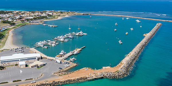
Port Denison Boat Harbour is located 3 kilometres from Dongara town centre, 359 kilometres north of Perth.
The harbour is enclosed by the east and west breakwaters and is home to one of the State’s largest rock lobster fishing fleets.
The harbour offers safe and convenient boat pens and moorings, a service jetty and wharf, fuelling and maintenance facilities, jinker ramp, and public toilets.
Port Denison is a popular holiday destination for fishing, sailing, surfing, wind surfing and swimming.
Harbour facilities
Service jetty and wharf
The concrete jetty and service wharf provide single, three phase power, water, lighting and fuel.
Service wharf load limits
- Berth load: 50 tonne displacement vessel berthing at a maximum of 0.3 m/s at a maximum approach angle of 15°
- Stack load: 500 kg/m²
- Vehicle load: 8 tonne gross weight
Service jetty load limits - upper level
- Berth load: Max 50 tonne displacement vessel berthing at a maximum of 0.3 m/s at a maximum approach angle of 15°
- Stack load: 2000 kg/m²
- Crane load: 8 tonne gross weight
- Vehicle load: M18 standard load
Jinker ramp
A commercial jinker ramp, constructed and administered by the Dongara Professional Fishermen’s Association, is located near the service jetty to the north-east of the harbour.
Fuelling facility
Fuel is available from the service jetty and is provided by Comen Fuel WA. The fuel service is available 24 hours a day, 7 days a week by credit card.
Phone: 08 9652 1511
Email: admin@comen.com.au
Heavy lift facility
The heavy lift facility is located on the harbour side of the northern breakwater adjacent to the jinker ramp and is operated by Bass Marine.
Phone: 08 9927 1372
Email: admin@bassmarine.com.au
Fishing platform and fish cleaning table
A fishing platform and fish cleaning table is located on the ocean side of the northern breakwater, operated by the Shire of Irwin. Fishers are encouraged to park their cars in the sealed car park.
Boat ramp
To the south of the harbour there is a public dual lane concrete boat ramp with a catwalk and sealed car and boat trailer parking, operated by the Shire of Irwin.
Parking
There are 2 car parks to the north-east of the harbour. One is located near the pens, and another is near the service jetty. Further public car parking is located south of the harbour near the boat ramp and universal access public toilets.
Public toilets
There are public toilets near the service jetty in the north-east car park. Universal access public toilets are located near the boat ramp south of the harbour and are operated by the Shire of Irwin.
Harbour swing moorings
Harbour swing moorings are registered by the Department of Transport and Major Infrastructure (DTMI) and the mooring apparatus is privately owned. No public moorings are available.
Expired flare disposal
Flare disposal is available nearby at the Port Denison Volunteer Marine Sea Rescue Group, Point Leander Drive, Port Denison.
Waterway entrance channel
Latitude: -29.273 S
Longitude: 114.914 E
Boat pens
Number of pens
48 pens
Pen lengths
Options include:
- 1 x 15m pen
- 47 x 20m pen
Services
Single phase and three power, water and lighting.
There are also 12 dinghy pens.
Fees and charges (2026/27)
See below for current fees at Port Denison Boat Harbour.
All fees quoted are inclusive of GST and should be paid in advance.
Fees are charged per metre of the pen length and should be paid in advance.
Fixed alongside berth
| Fee description | Amount |
|---|---|
| 12 months | $606.40 |
| 3 months or more per month | $55.30 |
| 1 month | $90.95 |
| 1 week | $27.25 |
Fixed pen with walkway
| Fee description | Amount |
|---|---|
| 12 months | $606.40 |
| 3 months or more per month | $55.30 |
| 1 month | $90.95 |
| 1 week | $27.25 |
Use of dinghy pens
| Fee description | Amount |
|---|---|
| 12 months paid in advance, per vessel | $464.90 |
User installed and maintained harbour swing mooring
| Fee description | Amount |
|---|---|
| 12 months | $151.60 |
| 3 months or more per month | $13.80 |
| 1 month | $22.70 |
| 1 week | $6.80 |
| 1 day | $3.00 |
Other facility fees
| Fee description | Amount |
|---|---|
| Electricity supply - metered | COST |
| Water supply - metered | COST |
| Rubbish removal - including any not placed in supplied bins or containers not removed; waste oil in excess of 150 litres; or rubbish from source other than fee paying vessel. | COST |
Service jetty fees
There are fees and conditions for use for service jetties and wharves at DTMI managed maritime facilities.
Find out more about service jetty and wharf fees.
Apply for a boat pen
DTMI’s vessel accommodation is offered on a casual, short term and long term basis and is always in high demand. Submit the enquiry form to find out if a pen is available.
Ready to apply?
Once you have spoken with one of our Harbour Officers to confirm availability, fill in either the waitlist or vessel accommodation application form below and familiarise yourself with important terms and conditions.
Weather and conditions
Before heading out on the water, be sure to check the current:
Bureau of Meteorology (BOM) resources: