The Fremantle Harbours Master Plan will guide the development of the Fremantle Fishing Boat, Challenger and Success Harbours for the next 40 years.
The aspirational master plan identifies opportunities for improved infrastructure, ways to enhance access and public spaces, and new development sites, while maintaining an authentic working boat harbour. It aims to reconnect the city centre, port and harbours to create a livelier, more accessible waterfront.
The plan proposes:
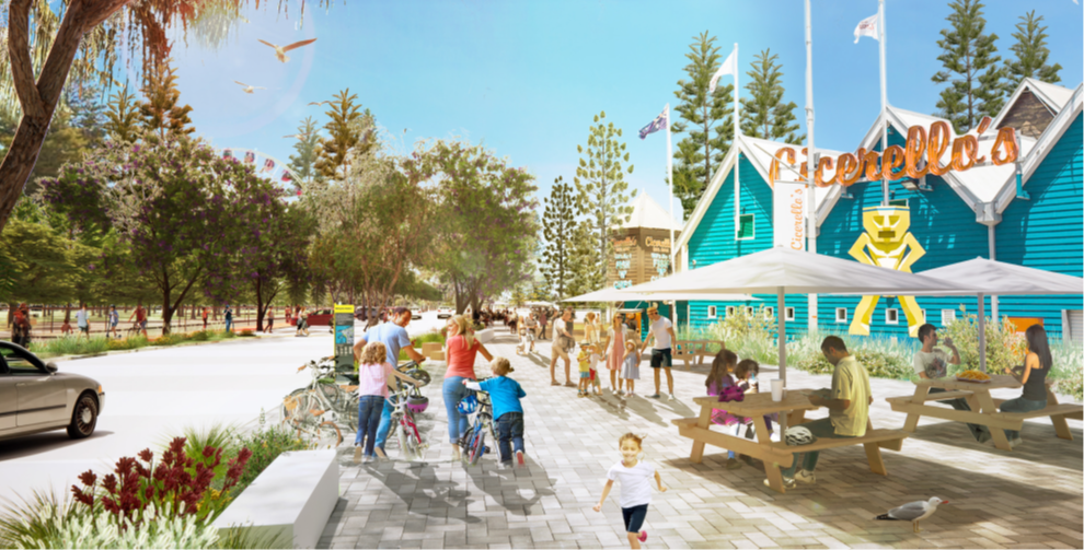
- converting Mews Road into a promenade with a shared use plaza for festivals and events;
- improving connections through well-defined gateway entries with the extension of Norfolk Street, an upgrade of Wardan Lane to full movement and by strengthening the existing central Esplanade Reserve pedestrian entry;
- enhanced public spaces including new, safer play areas for children;
- more bicycle parking and better public transport integration;
- maintaining an authentic working boat harbour focussing on the fishing industry, maritime services and associated commercial enterprises by retaining but relocating a large commercial boat lifting facility, providing for the berthing and provisioning of the growing superyacht sector and by promoting value-added fishing and commercial maritime activities; and
- creating new development sites opposite Bathers Beach House and where the boat lifter currently operates.
The Department of Transport and Major Infrastructure (DTMI) developed the master plan in collaboration with the Department of Planning, Lands and Heritage and the City of Fremantle, under the oversight of the Fremantle Harbours Activation Master Plan Steering Group.
Project background
DTMI and the City of Fremantle recognised there was a need for a plan to guide harbour development and reconnect the harbours, port and city centre.
In 2019, DTMI began work with the City of Fremantle; the Department of Planning, Lands and Heritage (DPLH); other government agencies; and stakeholder groups to create a renewed vision for the harbours.
In 2020, DTMI formed the Fremantle Harbours Activation Master Plan Steering Group. The Steering Group, which included members from the City and DPLH, considered the key issues associated with the development of the harbours and prepared a draft master plan.
The draft master plan was released to the public for feedback in July 2022. The final master plan release in September 2023 reflects the feedback received.
Delivering the master plan
DTMI is preparing an implementation strategy for the master plan, which:
- sets out how we will work with key stakeholders to achieve the vision of the master plan, and
- identifies several priority planning projects - several of which have commenced.
Priority planning projects currently underway to inform delivery of the vision include:
- Shared Path Upgrade, to improve pedestrian and cycling links to the harbour and Fremantle Station. The project will deliver improvements to the cycle lanes accessing the harbours, and an activated pedestrian and cycle arrival space on Mews Road near Wardan Lane, including bike parking, landscaping, and signage.
- Fremantle Harbours Access Plan, which will aim to develop the best possible transport planning solutions for the harbours. It will identify how DTMI can enhance access and walkability to and within the harbours and manage car access and parking to support the master plan’s vision.
- Harbour Design Guidelines, which will be used to the inform the design and built form of the harbours.
- Boat Lifter Relocation feasibility studies, refining concepts and preparing a business case for contemporary boat lifting facilities in Fremantle Fishing Boat Harbour.
DTMI will engage with stakeholders and community on the projects arising from the master plan, and will share updates and progress at community open days.
If you would like to receive invitations for consultation and open days, email the project team at Fremantleharboursmasterplan@transport.wa.gov.au.
Fremantle harbours waterfront precinct development guide
Informed by the Fremantle Harbours Master Plan the Fremantle Harbours Waterfront Precinct Development Guide explains our vision, design principles and development objectives to assist leaseholders when proposing development.
Frequently asked questions
The draft master plan includes the Fremantle Fishing Boat Harbour and Challenger and Success Harbours. It also considers the adjacent Esplanade Park, Bathers Beach, the rail line and Fremantle Port, as well as nearby residential and commercial development.
Strong community support was received following the release of the draft plan in September with more than 1,000 people having their say or sharing the information. Feedback provided has seen greater clarity provided on the intent of the document reinforcing its role as a visionary plan which will be supported by detailed planning studies to address built form, design, access and parking. The final plan also provides more detail about community facilities and infrastructure.
Opportunities to make the waterfront more accessible include:
- Two-way access at Wardan Lane so that Mews Road can be used for events and activities without impacting access to harbour operations.
- Providing a view corridor and additional access from city centre to the harbour by extending Norfolk Street directly into Mews Road at the southern end of harbour.
- Closing the Arundel Street entrance which will reduce traffic along The Esplanade and improve safety and access for cyclists and pedestrians.
The master plan creates an opportunity for a new event and activity space at Mews Road by closing sections when required and changing road access points. Mews Road will be pedestrian-focused, reflecting cosmopolitan waterfront precincts around the world and new plazas and park lands will be developed through the Harbour.
The Master Plan envisages new land parcels that will be developed over the next 40 years that will bring people and life back to the water. New development will allow for accommodation in a mixed-use setting to bring people into the area night and day.
The master plan identifies opportunities to improve links between the port, Norfolk Street, The Esplanade and the city centre. This will allow improvements to public spaces, pedestrian walkways, and create better visibility and views to the water.
DTMI manages the Fremantle Fishing Boat, Challenger and Success Harbours and will lead the implementation of the final master plan. DTMI will work with relevant stakeholders including City of Fremantle, Fremantle Port Authority and the Public Transport Authority to ensure all the current plans align and deliver the best outcomes for the Waterfront Precincts throughout Fremantle.